|
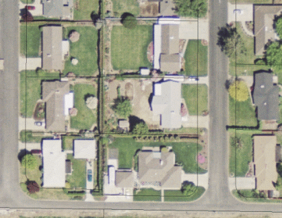
What are ortho-photographs? Ortho-photographs are aerial photographs registered to a map coordinate system and can be scaled from, that is, you can measure distances on the photograph. Why are they different from simple aerial photographs? Measurements from regular aerial photographs are not consistent across the entire image. Ground terrain, the camera lens and other factors makes measuring distances inaccurate. Ortho-rectifying removes most of those errors. What are ortho-photographs used for? Ortho-photographs are most often requested by landowners who wish to see an aerial view of their property, usually with parcel lines as in the example below:
Landowners use ortho-photos to locate features surrounding their property such as orchards, streams, wetlands and other critical areas, residential areas, and businesses. Realtors, engineering and surveying firms, construction companies, developers, and independent planners also request ortho-photos. This is our most popular map product. We currently have ortho-photography from 1992, 1998, 2002, 2005 and 2006 covering much of the developed areas of Yakima County. We also have ortho-photography for the Yakima Urban area flown in the spring of 2004 and a larger flight is planned for the spring of 2008. How can I get an ortho-photograph?
Just call (509) 574-2990, 574-2992, 574-2993, 574-2994, or 574-2995, email gis@co.yakima.wa.us or stop by the Yakima County Courthouse-Room 106, 128 N 2nd Street, Yakima, WA 98901 and we can make an ortho-photograph for you on the spot. The cost is $5.00 for a 8.5" x 11" or 11" x 17" color map. We can also make larger size maps with ortho-photography: A 24" x 36" map is $10.00 A 36" x 48" map is $15.00 Caveat Ortho-photographs are a useful planning tool because they provide a 'birds-eye' view of your property and the relative location of the property lines. However, they should not be used to resolve boundary disputes. If you need to resolve a boundary dispute you need a licensed surveyor. |